
NASA has just presented the first pictures taken by its air analysis tool placed in geostationary orbit a little earlier this year. The goal is to monitor the state and evolution of pollution in the United States, very precisely, neighborhood by neighborhood. Soon, this same device will be deployed for Europe and Asia.
The American space agency (NASA) has therefore just unveiled its first maps of the state of pollution in the United States, drawn up using its space instrument TEMPO (for “Tropospheric Emissions: Monitoring of Pollution”). Dedicated to the observation of the main atmospheric pollutants across North America, it is installed on a telecommunications satellite placed in a geostationary orbit more than 35 km above the equator.
Detect hidden pollution
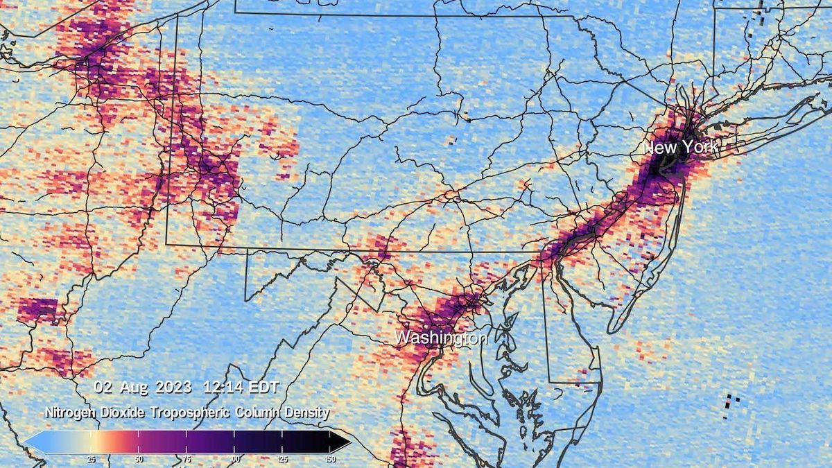
TEMPO detects pollution hidden in reflected sunlight all day long. It can thus measure the levels of various pollutants, starting with ozone, nitrogen dioxide, sulfur dioxide, aerosols and water vapour.
Unsurprisingly, pollution is obviously concentrated in metropolitan areas. These first shots show high levels of nitrogen dioxide over cities in the morning, but also over major highways. It should be noted, however, that over the course of the day, this morning pollution tends to dissipate, before increasing again at the end of the afternoon, during rush hour in transport.
Soon in Europe and Asia?
The first measurements date from the beginning of August. An adjustment phase for this tool is planned until October, when TEMPO should be fully operational. This data will then be shared with various partners, including the Environmental Protection Agency (EPA) and the US Oceanic and Atmospheric Observation Agency (NOAA).
The idea is to help scientists better study air quality in North America, with data reported hourly. In the examples provided by NASA, it will help to better understand the effects of rush hour traffic, smoke and ash from forest fires or the impact of fertilizers on agricultural land. NASA’s ambition is for neighborhoods across the country to benefit from TEMPO data for ‘decades to come’
Note that TEMPO is part of a vast “climate plan” launched by the Biden administration. This tool should soon be installed on two other satellites, this time to observe air quality in Europe and Asia.